
Airspace Classes Explained: How to Read Them on a VFR Sectional Chart
The first time you unfold a sectional chart, it looks like someone spilled a box of crayons over Florida. Blue rings, magenta circles, dashed lines, fuzzy shading and tiny numbers everywhere.
Here's the good news: it's a system, and once you learn it, it clicks fast. In this post we'll break down the six classes of airspace in plain English, show you how each one is drawn on the chart, and then read a real piece of the Tampa Bay sectional together.
The six classes of airspace at a glance
U.S. airspace is split into controlled airspace (Classes A, B, C, D and E) and uncontrolled airspace (Class G). Here's what each one is, where you'll find it, and what you need to fly into it as a VFR pilot.
| Class | Where you'll find it | Typical shape | What a VFR pilot needs to enter |
|---|---|---|---|
| A | High above everything | 18,000 ft MSL up to FL600 | Not available to VFR flights. IFR flight plan and clearance only |
| B | Around the busiest airports, like Tampa International | Surface to about 10,000 ft MSL, shaped like an upside-down wedding cake | An ATC clearance ("cleared into the Class Bravo"), plus ADS-B Out and a Mode C transponder |
| C | Around busy airports with radar approach control | Surface to about 4,000 ft above the airport, with a 5 NM core and a shelf out to 10 NM starting at 1,200 ft | Two-way radio communication with ATC before you enter, plus ADS-B Out and Mode C |
| D | Around airports with an operating control tower | Surface to about 2,500 ft above the airport | Two-way radio communication with the tower before you enter |
| E | Most of the controlled sky that isn't A, B, C or D | Usually starts at 700 or 1,200 ft above ground (sometimes at the surface) | Nothing extra for VFR, but cloud clearance rules get stricter |
| G | Uncontrolled airspace near the ground | Surface up to where Class E begins | Nothing extra. It has the lowest weather minimums |
"Two-way radio communication" has a specific meaning. It's established when the controller answers using your call sign. If you hear "Aircraft calling, stand by," you haven't been cleared in yet. Stay out until they say your tail number.
For Class B, you need the actual words "cleared into the Class Bravo." A friendly "radar contact" doesn't count. Student pilots also need a specific logbook endorsement from their instructor before flying solo in Class B.
VFR weather minimums by airspace
Each class comes with its own visibility and cloud clearance rules. These are the ones you'll use most below 10,000 ft MSL, from 14 CFR 91.155:
| Airspace | Visibility | Distance from clouds |
|---|---|---|
| Class B | 3 statute miles | Clear of clouds |
| Class C, D and E | 3 statute miles | 500 ft below, 1,000 ft above, 2,000 ft horizontal |
| Class G, day, 1,200 ft AGL or lower | 1 statute mile | Clear of clouds |
| Class G, day, above 1,200 ft AGL | 1 statute mile | 500 ft below, 1,000 ft above, 2,000 ft horizontal |
Above 10,000 ft MSL in Class E and G, the minimums jump to 5 statute miles and 1,000 ft below, 1,000 ft above and 1 statute mile horizontal from clouds.
How airspace looks on a sectional chart
A sectional chart is the VFR pilot's road map. Each one covers a big piece of the country at a scale of 1:500,000, and the FAA updates them every 56 days. The airspace is drawn with a small set of symbols, and these eight cover most of what you'll see:
Two things trip up almost every new student. First, altitudes on airspace labels are in hundreds of feet MSL (above sea level), not above the ground. A Class B label of 100/30 means the top is 10,000 ft MSL and the floor is 3,000 ft MSL. Second, the shaded Class E bands are one-sided. The shading sits on the side where Class E starts at 700 or 1,200 ft. On the other side, it starts higher.
Let's read the real thing: Tampa Bay
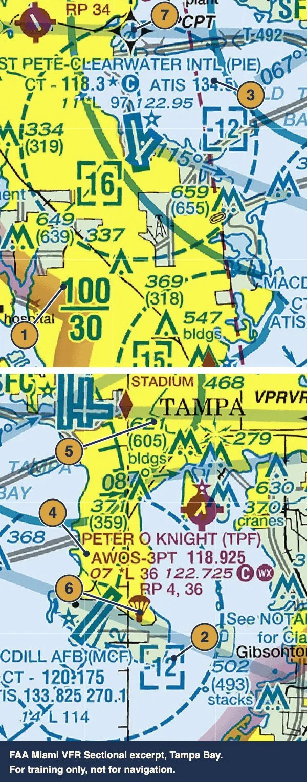
Here's a real excerpt from the FAA Miami sectional, right over Tampa Bay. This is the airspace you'll fly in when you train with us. Match each number to the table below.
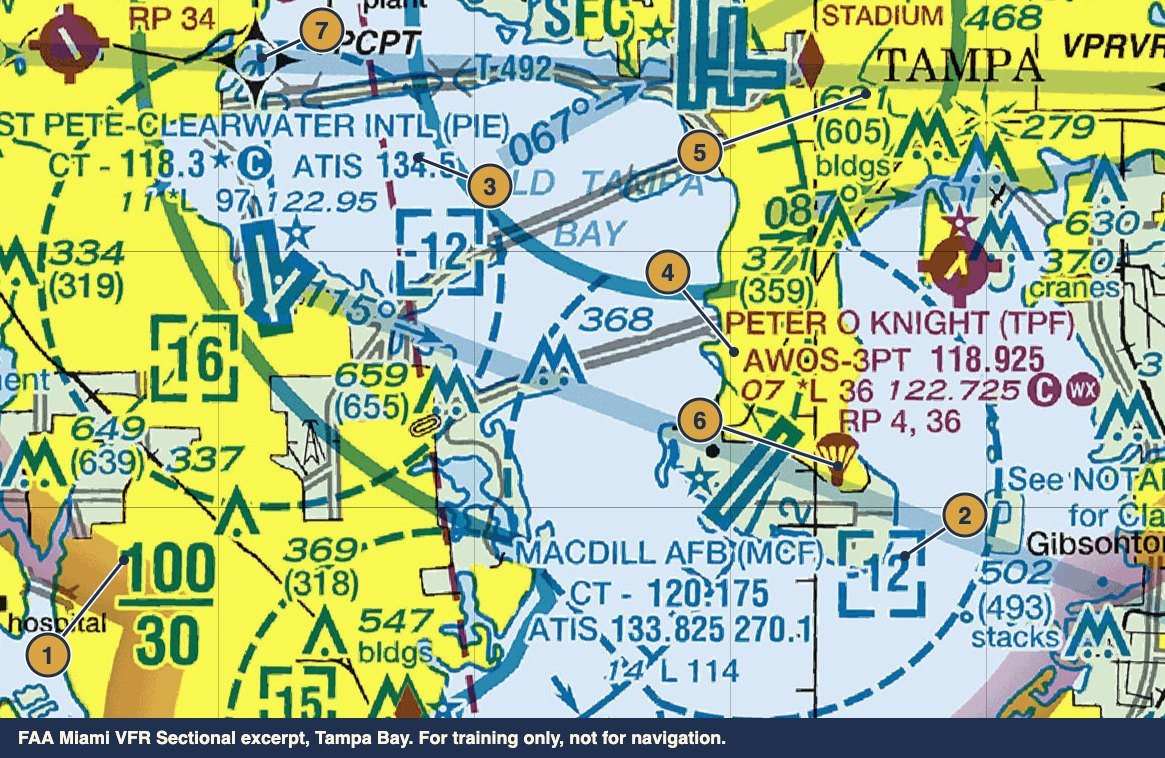
| # | What you're looking at | What it means |
|---|---|---|
| 1 | 100 over 30, next to a solid blue line | This piece of Tampa's Class B starts at 3,000 ft MSL and tops out at 10,000 ft MSL. Fly below 3,000 ft here and you're under it, not in it. |
| 2 | A dashed blue line with -12 in a dashed box | MacDill AFB's Class D. The minus sign means it goes up to, but not including, 1,200 ft MSL, which is where Tampa's Class B begins above it. |
| 3 | A blue airport data block: CT - 118.3, a star and a C | St. Pete–Clearwater International. Blue means it has a control tower. 118.3 is the tower frequency, the star means the tower is part-time, and the C means 118.3 becomes the CTAF when the tower is closed. 11 is the field elevation in feet, 97 means the longest runway is 9,700 ft, and 122.95 is UNICOM. |
| 4 | A magenta airport data block for Peter O. Knight (TPF) | Magenta means no control tower. AWOS-3PT 118.925 is the automated weather. 07 is the field elevation, 36 means a 3,600 ft runway, 122.725 with the C is the CTAF you self-announce on, and RP 4, 36 means right traffic for runways 4 and 36. |
| 5 | 621 (605) next to an obstacle symbol | The top of the obstacle is 621 ft MSL. The number in parentheses is its height above the ground, 605 ft AGL. |
| 6 | A small parachute symbol | A parachute jumping area. Watch for skydivers and check the Chart Supplement for details. |
| 7 | A four-point star labeled VPCPT | A VFR waypoint. Anything starting with VP is a named point you can load into your GPS, and ATC may use it to route you. |
Notice how the *L shows up in both airport data blocks. It means lighting limitations exist, so check the Chart Supplement before you plan a night flight there.
Where Tampa Executive fits in
Our home base, Tampa Executive Airport (KVDF), is a non-towered airport, so it's drawn in magenta and you'll self-announce on the CTAF, 122.7. It sits close to Tampa's Class B shelves, which is why we brief our altitudes on every departure and arrival. Staying under a shelf or talking to Tampa Approach becomes second nature fast.
One quirk worth knowing: the Miami and Jacksonville sectionals meet at 28° north, which runs right through the Tampa area. For flights around Tampa Bay, many pilots also carry the Tampa Terminal Area Chart, which shows the Class B in much more detail.
Quick tips for reading any sectional
| Tip | Why it matters |
|---|---|
| Check the edition date | Sectionals update every 56 days. An outdated chart can be missing new obstacles or airspace changes. |
| Read airspace labels as MSL | Airspace floors and ceilings are above sea level, while obstacle heights in parentheses are above ground. |
| Find the floor, not just the ring | Being inside a Class B ring on the chart doesn't mean you're in Class B. It depends on your altitude. |
| Look for magenta versus blue | Magenta airports have no tower. Blue airports have one, so you'll need to talk before you enter. |
| Check NOTAMs and TFRs | Temporary flight restrictions don't appear on the printed chart. Always check before you fly. |
See it from the air
Reading airspace on paper is one thing. Seeing those blue and magenta lines line up with real landmarks out the window is where it really clicks.
Book a $199 discovery flight at Tampa Executive Airport, and we'll point out the airspace around Tampa Bay while you fly.
